Zlatibor is located in the south-western Serbia and belongs to the Zlatibor district, ie. Municipality Čajetina. Spatially limited sinter valley and the mountains in the northwest of Tara, mountain Murtenica in the southeast valley of the river Susica in the north and the south of the river Uvac.
Length of Zlatibor is 55 km and the width of 22 km, so that the mountain covers an area of 1,016 km2. Zlatibor belongs to the Vlach mountains, Dinaric direction. In its composition contains predominantly the “green wall” – serpentine. Besides serpentine prevailing limestone, causing there 98 caves and 44 pits. The most famous caves in the area of Zlatibor are Rakovička caves and cave-feet, which is the greatest form of karst topography.
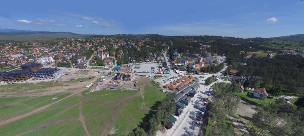
Zlatibor is a wavy mountain plateau at about 1,000 m above sea level, with lush pastures, clear mountain rivers and streams. In significantly covered with pine, fir and spruce forests. The highest peaks are Tornik (1.496 m), Brijac na Murtenici (1,462 m) and Čigota (1,422 m).
Zlatibor is rich with river flows. The southern part of the river Uvac runs strong and deep sump and very beautiful canyons. Under the northwest branch Murtenica, the Emperor Fields springs Black Rzav and flows through the central part of Zlatibor plateau. The eastern border runs Big Rzav, while the northern part of the mountain flows the river Susica. On Zlatibor there are two artificial lakes: The big artificial lake in Ribnica on the river Crni Rzav and small lake in the center of the tourist resort Zlatibor, built for tourist purposes.
Zlatibor has the characteristics of sub-alpine climate characterized by long, cold winters and hot summers with fresher evenings. The warmest is in August when the average temperature is 17.9 ° C degrees. Mean temperatures in winter range from -4.8 ° C to 2.8 ° C. Average number of days with snow cover is 114.2, which is an advantage for skiing during the winter period. Snow falls on average 64.5 days per year.
For the official beginning of tourism on Zlatibor is considered the arrival of King Aleksandar Obrenovic on Kulaševac 1893, when the place got its name – “Kraljeve vode’’ (‘’King’s Water’’).
Dužina Zlatibora je 55 km, a širina 22 km, tako da planina zahvata površinu od 1.016 km2. Zlatibor pripada grupi starovlaških planina, dinarskog pravca pružanja. U svom sastavu sadrži pretežno “zelene stene” – serpentine. Pored serpentina preovlađuje krečnjak, usled čega postoji 98 pećina i 44 jame. Najpoznatije pećine u predelu Zlatibora su Rakovička pećina i pećina Stopića, koja predstavlja i najveći oblik kraškog reljefa.
Zlatibor je talasasta planinska visoravan na oko 1.000 m nadmorske visine, bogata bujnim pašnjacima, bistrim planinskim rečicama i potocima. U značajnoj meri pokriven je borovim, jelovim i smrčevim šumama. Najviši vrhovi su: Tornik (1.496 m), Brijac na Murtenici (1.462 m) i Čigota (1.422 m).
Zlatibor je bogat i rečnim tokovima. Južnim delom teče snažna reka Uvac sa dubokim koritom i veoma lepim kanjonima. Ispod severozapadnih ogranaka Murtenice, iz Carevog Polja izvire Crni Rzav i teče centralnim delom zlatiborske visoravni. Istočnom granicom teče Veliki Rzav, dok severnim delom planine protiče reka Sušica. Na Zlatiboru postoje i dva veštačka jezera: Veliko veštačko jezero u Ribnici, na reci Crni Rzav i manje jezero u samom centru turističkog naselja Zlatibor, napravljeno za turističke potrebe.
Klima Zlatibora ima karakteristike subplaninske klime koju odlikuju duge i hladne zime i topla leta sa svežijim večerima. Najtoplije je u avgustu kada je prosečna temperatura 17,9 ºC stepeni. Srednje temperature tokom zime kreću se od -4,8 ºC do 2,8 ºC. Prosečan broj dana pod snežnim pokrivačem je 114,2, što predstavlja pogodnost za skijanje tokom zimskog perioda. Sneg pada u proseku 64,5 dana godišnje.
Za zvanični početak turizma na Zlatiboru smatra se dolazak kralja Aleksandra Obrenovića na Kulaševac 1893. godine, kada je kraj i dobio ime –”Kraljeve vode”.